Deadly Waves. Which Places Are Most at Risk for a Tsunami?
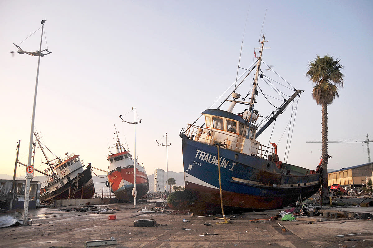
Ships are seen in the street after an earthquake and tsunami hit areas of central Chile on September 17, 2015. (Photo: Stringer/Reuters/Corbis)
Just minutes after an 8.3 magnitude earthquake struck off the coast of Chile last week, the country’s coastline began to experience tsunami waves — some up to 15 feet high, devastating costal towns in the northern-central region of the country.
At least 12 people were killed as a result of the powerful quake, centered just offshore, and over a million people had to be evacuated from their homes in order to escape the resulting tsunami — a tsunami that produced waves as far away as Japan.
In 2004, the world experienced the most destructive tsunami ever recorded, where over 225,000 people were killed across Asia within a matter of hours, and over a million were left homeless, as waves devastated the low-lying regions of the Indian Ocean.
These disasters highlight a worrying fact: that as more people head to coastal regions worldwide to live and vacation, tsunamis bear more of a threat than ever, from drowning or injury caused by debris in the water to destruction of homes and property. And there are certain places in the world that are much more at risk from these potentially deadly waves than others.
Yahoo Travel talked to an expert from the USGS (U.S Geological Survey) about which countries are most endangered and why, as well as what to do if you find yourself in one of these areas following an earthquake.
“You basically need three things to generate a tsunami,” explains Eric Geist, a research geophysicist from the US Geological Survey. "A large magnitude earthquake, 7.0 or higher, the earthquake has to be underwater, and it has to involve some kind of vertical plate movement."
A tsunami, which means “harbor wave” in Japanese, occurs when the aggressive movement of two tectonic plates under the ocean results in a dramatic displacement of water, causing huge waves. And while this water displacement can also occur from a landslide, meteor impact, volcanic eruption, or even a glacial carving, those causes are much less likely.
Related: 10 Years Later — Amazing Before and After Photos of the Thailand Tsunami Devastation

If you’re in a low-lying, coastal area when an earthquake hits, don’t wait for an official evacuation order; head to higher ground immediately. (Photo: iStock)
Tsunamis caused by earthquakes are usually only experienced in the subduction zones that occur almost entirely around the edges of the Pacific Ocean, also known as the Ring of Fire. And in this area, a tsunami can move at the speed of a jet airliner, according to Geist. "You are most at risk if you are right at a subduction zone, where a tsunami can occur within as little as three minutes,” Geist said. “That is a very short time to react.”
So what should you do if you find yourself in a low-lying, coastal area when an earthquake occurs?
“My advice to tourists on a beach anywhere in the world,” says Geist, “If you feel a strong earthquake or ground shaking you should immediately head to higher ground. I wouldn’t wait for any kind of official warning.”
Another sign to look out for that might signify an impending tsunami is the rapid withdrawal of coastal water. “If you see any unusual wave activity or water going far out, that is an immediate sign that a tsunami is on the way,” Geist explains.
Related: Indonesian Town Remembers Deadly Tsunami with Haunting Exhibits
According to Geist, the worst place to be is in the water. “Sometimes people see that and they think ‘Oh, let’s go explore the sea bottom,’ but that is the last thing that you want to do,” he said. Unlike regular wind-generated waves — which you can avoid if you’re most snorkeling or scuba diving — tsunami waves are different because they go all the way to the bottom of the ocean. “They are very deceptive that way,” according to Geist. “Looking out from the beach you might not see much either but they are moving much faster than a regular wave."
So where exactly are you most at risk? Here is a list of locations that are more susceptible to a tsunami, with a few surprising spots:
Chile and Peru
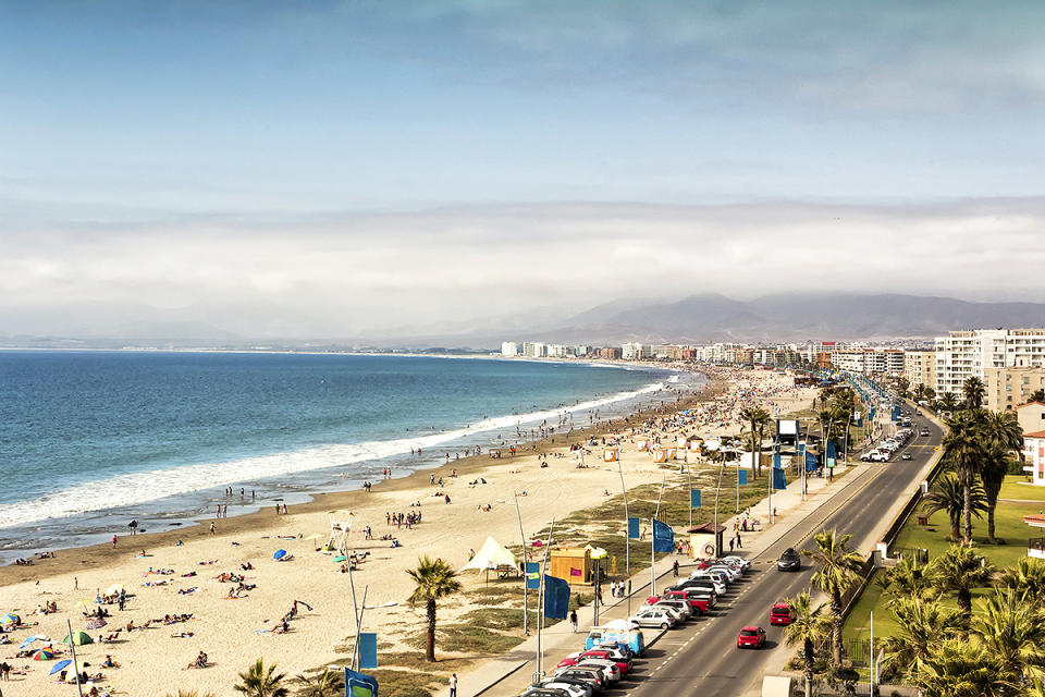
Coquimbo, Chile before the devastating events of last week. (Photo: Istock)
Approximately 100 miles from the Chile and Peru coastline, and running over 3,600 miles down the side of the continent lies an Oceanic trench called the Atacama Trench. Arguably the most active zone on earth, it has been responsible for some of the biggest earthquakes and tsunamis our planet has ever seen, including the Valdivia earthquake in 1960, which reached a magnitude of 9.5, the largest on record. Aside from last week’s event, the content has seen devastating tsunamis in both 1942 and 2010, with large loss of life and huge amounts of damage. Frighteningly, the 2010 earthquake resulted in a tsunami warning being issued for 53 countries.
Related: What To Do If You’re in an Earthquake
Chile and Peru have gone to great lengths to protect their population from such events by implementing early warning systems and building sea walls to protect coastal areas. "The [recent] Chile earthquake had an amazingly low loss of life,” says Robert Yeats, a professor of geology and geophysics at the Oregon State University. "A similar earthquake in 1939 killed more than 20,000. This points out how much Chile has done to prepare.”
West Coast of the U.S.

Cities and towns all along the coasts of California, Oregon, and Washington are at risk. (Photo: iStock)
Historically, the region has displayed vulnerability to tsunami waves. Following a massive earthquake in 1812, Santa Barbara fell victim to a huge wave that flooded the low lands up to a mile from the shore. And following the Great Alaskan Earthquake of March 1964, a tsunami killed 121 people in Alaska, Oregon, and California as waves battered the U.S. coastline. That earthquake is the second largest ever recorded, with a magnitude of 9.2.
In July of this year, theoretical physicist Michio Kaku, from the City College of New York, claimed that the Cascadia Subduction Zone — which stretches along the West Coast of North America from northern Vancouver Island to Cape Mendocino, California — has the potential to cause the worst natural disaster America has ever seen. “The Cascadia fault is an earthquake waiting to happen,” he explained to the Inquisitr. “We know it’s going to happen with energy 30 times the maximum energy of the San Andreas fault.”
This type of mega earthquake could create a gigantic tsunami that would devastate the coastal regions of California, Oregon, and Washington. Seismologists at the University of California - Riverside also recently used 3D computer models to show how a 7.7 magnitude earthquake could create waves reaching several miles inland in California’s Ventura County.
Japan

Japan is no stranger to tsunamis and has become the world leader in tsunami preparedness. (Photo: iStock)
Throughout history, tsunamis have occurred so frequently in Japan that they invented the word we use today to describe the phenomenon. Six of the 10 worst tsunamis ever recorded have devastated Japan, including the catastrophic Tohoku earthquake and tsunami that occurred on March 11, 2011 off the country’s North Pacific Coast. A 9 magnitude earthquake led to a 32-foot-high wave that swept on shore at a staggering 497 mph, killing 18,000 people and displacing almost a quarter of a million people. The earthquake also resulted in damage to the Fukushima Daiichi Nuclear Power Plant, which began leaking radioactive steam into the atmosphere.
Related: Travel Destinations an Earthquake Could Strike Next
Due to the nation’s experience with harbor waves, Japan has become the world leader in tsunami preparedness, spending billions on fitting buildings with shock absorbers and building high seas walls to protect low-lying coastal towns. It are also the only country on earth to have an early warning system for tsunamis generated by local earthquakes. Most countries are only capable of warning of tsunamis caused by distant earthquakes.
New Zealand

The islands of New Zealand are beautiful, but also at high risk for tsunamis. (Photo: Getty Images)
The Pacific islands of New Zealand have experienced 10 tsunamis over 16 feet in height since records began back in 1840. Most were caused by earthquakes on the sea floor, just off the country’s coastline. But New Zealand also has a high risk from other tsunami triggers, including landslides, volcanic eruptions, and distant earthquakes on the other side of the Pacific. In fact there are records of three big tsunamis caused by volcanic eruptions and three tsunamis caused by landslides on the islands, all of which caused damage to coastal towns.
India
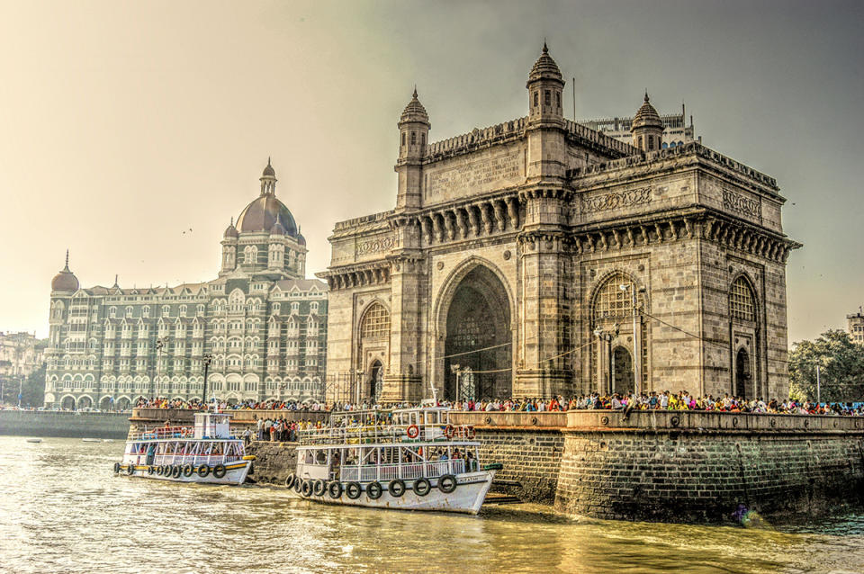
Recent studies have shows that devastating earthquakes in the Arabian Sea are possible, threatening destinations like Karachi, Muscat, Goa, and Mumbai. (Photo: iStock)
India was one of the countries most badly affected by the 2004 Indian Ocean earthquake and tsunami that resulted in the deaths of almost a quarter of a million people and billions of dollars in damage across 15 countries. A recent study by the University of Southampton, UK and the Pacific Research Centre, Canada, found that similar sized earthquakes are also possible in the Arabian Sea — on the opposite side of India from the 2004 quake. This suggests that the Western Indian Ocean region is more at risk from underwater earthquakes and tsunamis than previously thought, potentially affecting Pakistan, Oman, Iran, and India.
Grand Banks, Newfoundland

A 1929 earthquake destroyed the coastal towns on the Burin Peninsula in Newfoundland and another one could be devastating to the area. (Photo: Radius Images/Corbis)
In November 1929, a 7.2-magnitude earthquake occurred in the Atlantic Ocean just off the south coast of Newfoundland in an area called the Laurentian Slope Seismic Zone. The quake triggered a large underwater landslide, leading to a tsunami that hit the coast in three waves, each over nine feet high. The tsunami hit the coast at 80 mph and destroyed coastal communities on the Burin Peninsula leaving 28 people dead and 10,000 homeless.
While there is still regular seismic activity around the East Coast of the U.S., the area is more at risk from tsunami waves created by earthquake or volcanic activity on the opposite side of the Atlantic Ocean.
Italy
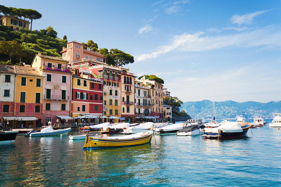
The stunning coastal towns of Italy are incredibly popular tourist destinations. Unfortunately, a recent study showed that the whole Mediterranean region is at risk for giant tsunami waves. (Photo: Getty Images)
On December 28 1908, a 7.2-magnitude earthquake rocked the Italian cities of Messina and Reggio Calabria, damaging 90 percent of the buildings in the region and killing an estimated 40,000 people. The quake also caused a huge landslide, resulting in an 26-foot-high tsunami that killed an additional 2,000 people.
Related: WATCH: How to Survive Anything, from a Plane Crash to a Tsunami
Worryingly, a study published in the Ocean Science Journal just last month claims that the whole Mediterranean region is at risk from giant tsunami waves caused by earthquakes from the African tectonic plate sliding underneath the Eurasian plate. The study claims that over 130 million people who live in the coastal areas are at risk along with many of the world’s most popular tourist destinations.
Morocco

A volcanic eruption in the Canary Islands could spell out major disaster for Morocco and the rest of the African coast. (Photo: Nadia Isakova/JAI/Corbis)
Scientists at the University College London claim that the West Coast of Africa, including Morocco, is at huge risk of a tsunami created by a volcanic eruption in the Canary Islands. The island of La Palma was created 3 to 4 million years ago through submarine volcanic activity and is to this day the most volcanically active of all the Canary Islands. Approximately half a million years ago, the volcano collapsed, creating a giant landslide as the huge natural formation fell into the ocean. Scientists say a repeat of such an event could create a megatsunami that would devastate the African coast.
Portugal

Lisbon has felt the effects of a huge tsunami before and studies have shown another could happen in the future. (Photo: iStock)
The Great Lisbon Earthquake occurred on November 1, 1755 almost 400 feet off the Atlantic coast and reached a magnitude of 9.0. The quake caused huge amounts of damage in both Portugal and Morocco, where up to 50,000 people are believed to have died. Forty minutes after the original quake, a huge wall of water engulfed the harbor and downtown areas, as well as large areas in the Algarve coastal region, destroying coastal fortresses, homes, and fishing ports. Tsunami waves also hit the North coast of Africa and spread across the Atlantic, reaching Barbados and the Caribbean. A study released by the European Institute for Marine Studies in 2004, claims that continued plate activity in the region could result in another equally as devastating earthquake and tsunami in the future.
WATCH: Mongolia’s Capital City, where Wealth and Poverty Collide
Let Yahoo Travel inspire you every day. Hang out with us on Facebook, Twitter, Instagram, and Pinterest. Check out our original adventure travel series A Broad Abroad.

